
Last weekend the Trans Mountain Pipeline had a spill at its Sumas Pump Station in Abbotsford. According to Trans Mountain the
Initial estimates are that 150-190 cubic metres (940-1195 barrels) of light crude was released and was fully contained on Trans Mountain property.
The release is related to a fitting on a small diameter (1”) piece of pipe connected to the mainline. No construction or Expansion Project activity was underway at the pump station. The incident was identified when an alarm was received at Trans Mountain’s control centre. The pipeline was immediately shut down and crews arrived at the site within an hour of shutdown.
Here are some photos taken by Trans Mountain immediately after the spill, and shared with the media.
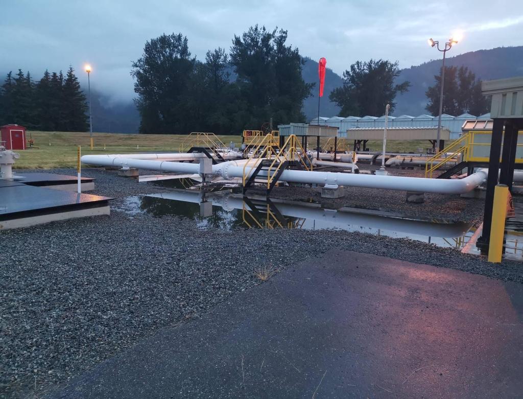
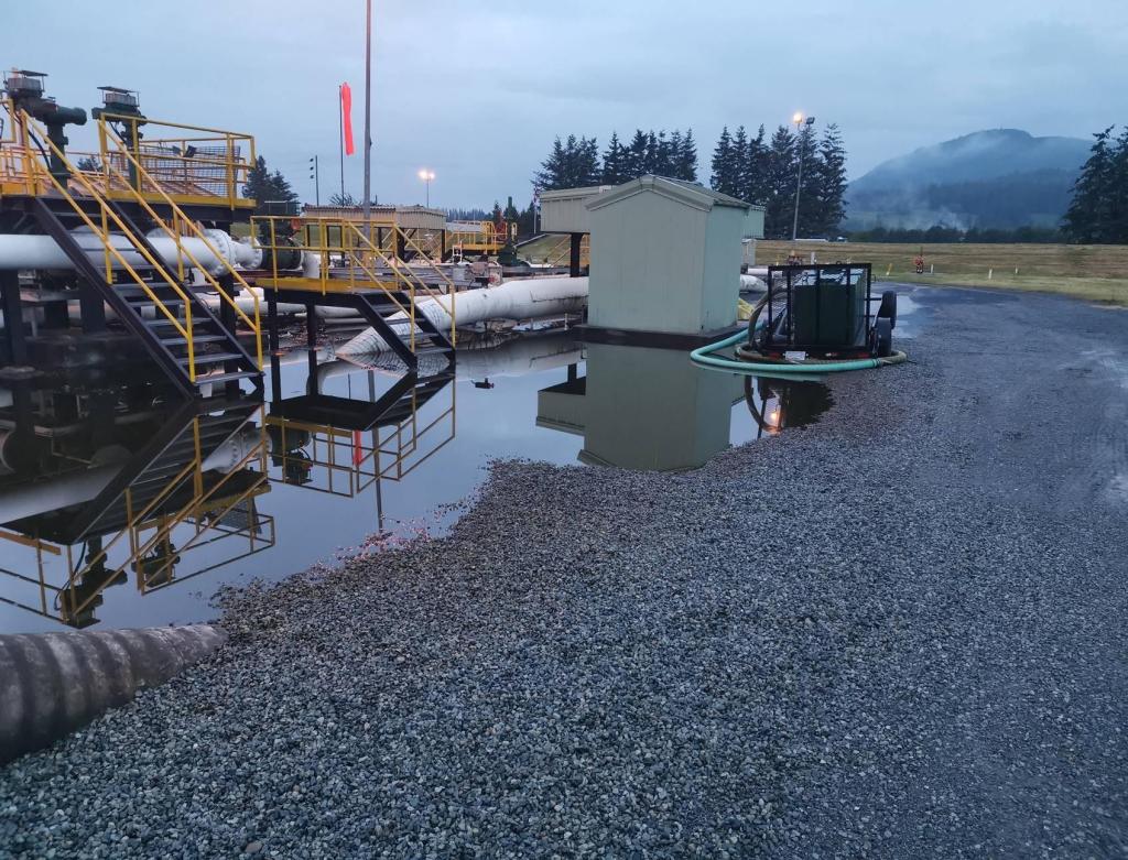
For those unaware of how these facilities are designed, the area where the spill occurred is designed to keep spills nearby. It is at a lower grade than the surrounding area, is gravel and asphalt-covered, and surrounded by berms. From the photos it is clear that the vast majority of the spill was contained to a graveled containment area. Trans Mountain has indicated that they have recovered most of the liquids but soil impacts remain and will need to be cleaned up.
Further investigation, after the initial reports, indicated that some oily water had escaped the initial containment and had been released into the adjacent field, which is owned by Trans Mountain. The field is often used by neighbours for grazing their cattle. This field is understood to be home to the monitoring well network used for ongoing monitoring of groundwater conditions near their facility.
Our good friends at the Wilderness Committee presented a press release including the photo below which they distributed to the media for general use.
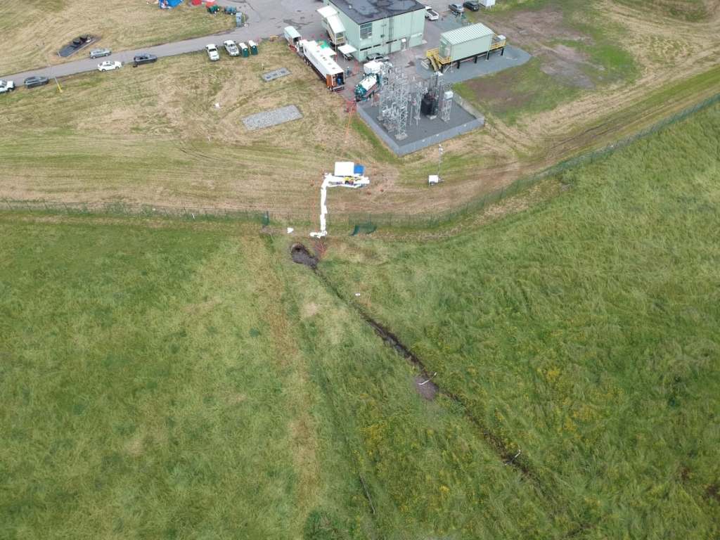
Looking carefully, one can see four oil spill booms in the ditch leading from the water discharge point. Two are fully soaked and two are partially affected. This is consistent with a release of oily water, likely from the facility’s oil/water separator before it was shut down. What is not visible is a line of spill pads that would be emplaced if there was a major spill to be cleaned up.
A couple days later the Wilderness Committee prepared a mini-video on the spill:
Immediately following the spill the Wilderness Committee’s point man on this topic Peter McCartney (the gentleman who narrates the video known by his Twitter name @Climate_Pete) made it into the newscasts making clearly incorrect claims, like that it was lucky the spill was sweet crude because had it been bitumen it would have been much harder to clean up.
In this blog post I want to fact-check the Wilderness Committee response to this spill as, in my opinion, it shows a clear pattern of misinformation and simple ignorance about this topic.
The weird part about the misinformation is some of the things they have stated are obviously wrong. Less than ten seconds into the video Pete claims “Trans Mountain has spilled 150,000 to 190,000 L of crude into the local ecology.” In the press release he put it: “We’re talking about a major oil spill in a waterlogged field that sits above the Sumas aquifer,”
Except we know this to be categorically false. As presented in the photos, the spill was mostly controlled in a containment area. 150,000 Liters did not reach “the local ecology“. There was no “major oil spill in a waterlogged field“.
In the video, Pete then goes into a brief discussion about hydrology, which, as I will detail later, is simply wrong. To summarize, the shallow subsurface in this area (where the spill would migrate) is separated from the local aquifer by a layer of silty-clay. Pete doesn’t appear to understand hydrology even as he opines on the subject on various media platforms.
Pete then goes on to say (at around 48 seconds) that there have been 4 spills in the last 15 years in the territory. Except that is not true either. To support this claim he flashes this list of spills from the Trans Mountain web site.
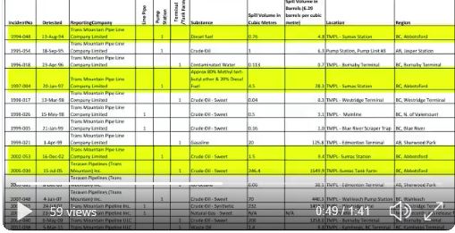
Since the view is not terribly clear I went to the original source and pulled out the page here.
Looking carefully, the dates he has highlighted are from 2005, 2002, 1997 and 1994. Now unless Pete uses a different sort of calendar than me, 1994 is not within 15 years of 2020. Moreover, that spill from 2005 was actually at the Sumas Tank Farm which is several kilometers away, up a mountain from the current spill. From a hydrological perspective it could be on another planet since it is in a different aquifer (more on that later) and is hydraulically separated from that aquifer by hundred of meters of consolidated bedrock.
The records Pete presents show that the last spill at the Sumas Pump Station was 9.4 barrels of oil in 2002. The only other spills at this facility were in 1997 (28.3 barrels) and 1994 (4.8 barrels). For a pipeline that has operated since 1961 that is a pretty decent record. That is four spills since 1961 and absolutely does not represent 4 spills in 15 years.
Besides the erroneous statements, in the video, and in the press release, Pete makes a number of over-the-top claims:
- this is a disaster
- the extreme risks to local ecosystems
- a catastrophic spill
- a catastrophic oil spill in slow-motion
You can usually tell the difference between an activist and an informed observer by looking at how they approach a topic like this. Over-the-top rhetoric based on superficial or a detailed assessment of the facts is the activist approach. My responses tend towards the detailed assessment of the facts.
The first thing I thought to do was to try to understand what the subsurface looks like in the vicinity of the spill; as that would indicate the level of risk posed by this spill. This being BC we have lots of great resources to do just that.
To get an understanding of the area the first step would be to consult the BC Water Resources Atlas. It provides details of all the local water wells and information about the local aquifer. A search of the Atlas identifies a well in the Trans Mountain-owned field next to the facility that was drilled in 1957 (before the pipeline was completed). When we search the well record for this well we see that the stratigraphy in the area consists of almost 19 feet (5.8 m) of silty clay overlaying a sand and gravel water-bearing layer.
This information is incredibly useful to understand spill behaviour. Silty clay serves as a pretty effective barrier to the vertical migration of spills. In technical language, it forms a confining layer that prevents, or limits, the migration of both groundwater (and any spill) to the useful water-bearing layer (located according to the well record at “19 to 26 feet” (5.8 m to 7.9 m).
The Water Resource Atlas also provides information about the local aquifer, including the Aquifer 21 summary and the Aquifer fact sheet.
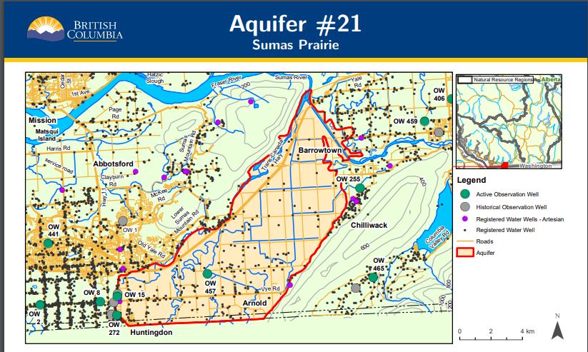
Look at that, the Sumas Prairie Aquifer is not hydraulically linked to the aquifer under Sumas Mountain. This is not surprising as the Sumas River would be where that aquifer drained.
These documents indicate that the groundwater surface in the Sumas Prairie Aquifer is at about 2-3 meters below the ground surface (mbgs) and that typical wells in the aquifer draw from around 9 mbgs. This is consistent with what the well log told us and is pretty good news so far. There is almost 6 m of protective silty clay between the surface spill and the aquifer and about 4 meters of that silty clay is water-bearing (but not capable of being used for drinking water).
The next thing to consider is how a spill in this material will be expected to move. For the next little bit I need to get a bit wonky…feel free to skip the next four paragraphs.
The first thing we know is that oil is a hydrophobic liquid with a specific gravity less than 1. That means any spill will attempt to migrate vertically through the vadose zone until it reaches the groundwater surface and then because it is both hydrophobic and less dense than water, will float along the groundwater surface before migrating laterally on that surface until it reaches a water body or naturally degrades.
A silty clay has a hydraulic conductivity in the 10-9 m/s range. That means it is really hard for liquids to flow through silty clay. Even more so if you are a hydrophobic liquid as that material will preferentially adhere to silt and clay particles.
The local hydraulic gradient is defined by the topography. As we know the Sumas Prairie is as flat as a pool table. It has a topographic change of less than 1 m per km (or less than 0.001 m/m). Combining these two facts generates a Darcy Velocity of 1 x 10-12 m/yr. Now when we incorporate the effective porosity of a silt and clay (0.10) we get an Effective Linear velocity of the groundwater in the area of 1 x 10-11 m/yr. This generates a 50 year travel distance of 0.02 m (20 centimeters).
A reminder, this calculation is simply the rate at which groundwater will move through this silty clay. A hydrocarbon plume, being hydrophobic, will have a high retardation factor (yes that is a technical term derived from the French word “retarder”) so will travel at a substantially slower rate than the associated groundwater. Given the nature of the aquifer, there is no reason to believe there would be a vertical gradient so the spill would not be expected to dive. The absence of any large water wells nearby means there are no anthropogenic driving forces involved either.
Okay wonky part done for a bit.
For those of you less interested in the details above, what the former paragraphs explain is that absent an outside driving force, a surface oil spill in the field will not get to the deeper drinking water aquifer. Rather, it will get caught up in the silty clay. That oil which eventually migrates to the groundwater surface (2 meters through virtually impermeable silty clay) will then migrate away from the spill at the stately rate of about 20 centimetres every 50 years on top of the groundwater and separated from the drinking water aquifer by 4 meters of silty clay.
From a clean-up perspective this is about as best a case as possible. To clean up the spill you just need to remove the top few centimetres (to a half meter or so) of impacted silty-clay and ship it away to a facility designed to treat the material.
Admittedly, the process will take time and will cost a bit of money (shipping and treating impacted soil can be expensive) but given the rate that plume would be moving they have a bit of time to deal with the problem.
Let’s be absolutely clear here. Any spill poses a risk. In a different location, with different subsurface conditions, a spill of this kind could indeed be a “disaster”. But the Wilderness Committee is not talking about another spill, somewhere else. It is talking about the June 13 spill at the Sumas Pump Station.
The Wilderness Committee representative, in the press, has repeatedly over-stated the volume of oil that escaped containment, has misrepresented the number of spills that have happened in this area and the risks posed by this particular spill. Admittedly, the last point is likely due to the fact that the organization appears to lack any scientific expertise on this topic. Their project lead is a journalism major and videographer with no apparent training, education or expertise in the natural sciences.
People keep asking me why I care? My issue is that local and national journalists keep going to “Climate Pete” for his take on these events and then simply report what he has to say without ever having an informed eye look over his claims to see if they make any scientific sense. Hearing him say things that are completely wrong is incredibly frustrating for someone who cares about evidence-based, decision-making. At some point the media has to stop giving him free media (earned media???) time to misinform the public. Moreover, it is time that people who actually understand this topic stand up and explain the facts so the public narrative isn’t dominated by misinformation.

Thanks Blair for yet another debunking of yet another manipulator.
I’ve stopped saying “thank you” concerning most of your posts, but that does not mean that I do not read them, nor that I don’t appreciate them. Most of your posts do warrant a wider audience.
Have you ever noticed signs that MSM reporters are reading your posts? In case they do and still prefer “Climate Pete”‘s take, wouldn’t that confirm that they are a sorry lot, not worthy of calling themselves independent reporters?
Otherwise, how could one reach them?, the ones with supposed integrity and unbiased reporting of well researched facts.
You do most of the work for them and they just let it pass by?
The alternative is that they write what they believe their readers want to be fed.
Altogether a sorry state of affairs.
Please keep caring.
LikeLiked by 3 people
OK I get this as a resource guy – but why does it take so long to see these spills – and to shut them down – a site like this given the importance of the day should be monitored in some way that shutdown is instant . ( cameras – electronics ) what am I missing here. ( mining guy )
LikeLike
They see the spill pretty quickly but to shut them down needs sequentially shutting down a whole lot of pumps and valves over the length of the pipeline. You can’t simply shut a valve like in a movie and have the entire thing shut down. Doing so would result in blow-outs along the length of the line.
LikeLiked by 1 person
Oil in any pipeline has mass. It weighs tons, thousands of tons, depending on length and pipe diameter. Add in the fact that flowing downhill, the oil has incredible momentum. Shutting down a pipeline requires that pumps first have to be stopped and then huge valves gradually closed in sequence, starting from way way back there. Miles away. It takes time, fantastic skill and extreme finesse to slow all that oil down. A valve cannot be instantly shut like the one we have in the kitchen sink or the pipe would be torn wide open. These are things the public simply do not know. Much of our fault is failing to educate the public and the politicians.
Universities also have to start teaching Investigative Journalism so that future reporters simply keep asking WHY. Given the quality of today’s News Media and commentators, I suspect that course was deleted from the education system decades ago.
LikeLiked by 1 person
Great article. Thanks for laying out the science. The intentional mis-representation of information to draw in public support for a cause is irresponsible and unethical and it’s important for the educated professionals to make sure the actual facts are available too. Even if they are wonky at timesm
LikeLiked by 1 person
Nicely done. Thank you for a true accounting of the facts. Possibly popsicle Pete should stay to what ever he might be good at —- and that would be anyone’s guess. Possibly someone has a suggestion for him. I will give him this, he is consistent and reliable, B.S. the whole way. Cheers
LikeLiked by 1 person
Pingback: Pipelines not only support Canada’s climate change goals, but also supports Canada’s economic goals. | Canadian Energy Network
This looks like about 200 or 250 Barrels on the ground to me, I wonder who decided it was more than a thousand.
LikeLiked by 1 person
Hydraulic conductivities or diffusivities are a bit difficult to measure accurately. I’d be a bit more conservative and double or triple your estimates of the Darcy velocity. Even that doesn’t change your conclusion about the danger to the aquifer though, particularly if the spill is remediated rapidly. Thanks for standing up for science. It is refreshing in an era when the media always looks to create controversy to sell their storyline rather than looking for the truth in an objective manner.
LikeLiked by 1 person
the last spill at the Sumas Pump Station was 9.4 barrels of oil in 2002.
The Exxon Valdez, now that was a spill. Less than 10 barrels is not going to scare anyone who doesn’t want to be scared. That much leaks naturally into the Gulf of Mexico every 10 minutes.
LikeLiked by 1 person
Pingback: More chemically-uninformed fear-mongering about the Trans Mountain Pipeline – this time about the dangers of diluted bitumen | A Chemist in Langley